Here is a video featuring the speakers at the Budd/Deschutes Environmental Stewardship Coalition signing ceremony earlier this week.
Category Archives: habitat
Budd/Deschutes Environmental Stewardship Coalition Update
UPDATE: Lacey City Council unanimously passed a resolution to sign the MOU last night. That means all have agreed and the signing ceremony on Nov. 29th is on.
The Olympia City Council voted unanimously to approve signing the MOU forming the Budd/Deschutes Environmental Stewardship Coalition tonight. The City of Yelm and the Squaxin Island Tribal Council unanimously voted in favor last week. If the City of Lacey approves the MOU this Thursday, there will be a signing ceremony at the Squaxin Museum on Nov. 29th at 3:30pm.
Here’s the video from that portion of last night’s meeting.
King 5 on the Deschutes Watershed Environmental Stewardship Coalition
New Deschutes Watershed Coalition Formed

On-the-ground habitat restoration projects will be the focus of a new coalition to jumpstart salmon productivity in the Deschutes River watershed. The Squaxin Island Tribe and the cities of Olympia, Lacey and Yelm are establishing the Deschutes Watershed Environmental Stewardship Coalition.
“The Deschutes coalition will be an ongoing alliance to fund and conduct on-the-ground projects to restore a healthy watershed,” said Andy Whitener, natural resources director for the tribe. “The coalition will put words into actions and start restoring productivity to the Deschutes River.”
Initial projects are slated for the 197-acre farm on the Deschutes River near Lake Lawrence that the cities recently purchased as part of mitigation for their new water rights.

Smith Farm near Lake Lawrence
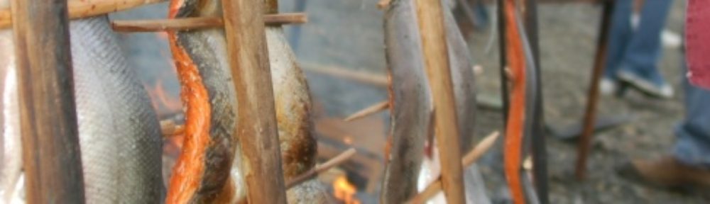
In the past, the Deschutes River was the largest producer of coho salmon in deep South Sound. A landslide in 1990 destroyed the most productive coho tributary in the watershed. “The impact of that landslide is still being felt throughout the watershed,” said John Konovsky, environmental program manager for the tribe. “But we know the Deschutes can be a productive salmon stream again.”
“Thirty years ago, we were seeing coho returns in the tens of thousands, now we’re talking about coho runs in the hundreds,” said Jeff Dickison, assistant natural resources director. “We need to get our hands dirty now to improve coho habitat and bring back stronger runs.”
Because the upper Deschutes River is relatively undeveloped – less than 10 percent has been converted to impervious surface – its still possible to restore salmon habitat and productivity. “If we restore some habitat and give these fish half a chance, they’ll recover,” Dickison said.
“The tribe’s treaty rights, economy and way of life are meaningless if we aren’t able to harvest salmon,” Whitener said. “Protecting and restoring salmon habitat is the most important thing we can do to restore coho and protect our treaty right to fish.”
Ancient Clam Gardens and Deepwater Sand Lance Habitat
Ancient clam gardens and deepwater sand lance habitats are just two of the many varied topics that were interesting at the biennial Salish Sea Ecosystem Conference held in Vancouver British Columbia this October.
Researchers fromSimonFraserUniversitylooked at the effectiveness of ancient shellfish gardens created onQuadraIslandinBritish Columbia. In these gardens, first nations’ peoples cleared rocks and small boulders down to the low ends of beaches to construct a sill. These cleared areas filled in with smaller sized sediment particles and created areas of higher quality clam habitat. The sill wall also acted to deter some predators and was thought to increase larval retention. When coupled with the first nations’ husbandry practices of removing predators to increase survival and removing competitors to increase growth they achieved clam aquaculture in a form that is not much different from what is practiced today.
Another interesting presentation was of a study using acoustic multibeam ecosounder data, seafloor video, and sediment samples to identify and sample subtidal habitat in the San Juan Channel of the Pacific sand lance. The sand lance is known to utilize near shore sandy substrates for burrowing emerging in daylight hours to forage in open water. Sandy upper intertidal beaches are used by adults for spawning and egg deposition. With this work, the natural history of the Pacific sand lance in its subtidal habitat has been greatly expanded. A predictive model that uses seafloor characteristics of sediment wave fields was developed to locate potential subtidal sand lance habitats. Densities of sand lance captured in this study were much higher than what has been reported intertidally, averaging 84 fish/m2 rather than only 5 fish/m2. What I found the most intriguing was the collection of a single sand lance egg found in one of 59 samples. This could indicate a low density late season subtidal spawning area that could be considered a “critical” habitat or just be an anomaly.
Overall the conference presented a wide variety of interesting topics and studies about theSalishSea, its inhabitants, and how they interact with each other. The Salish Sea Ecosystem Conference was an excellent opportunity to hear from and collaborate with researchers, policy makers, and natural resource managers.
Squaxin Island Tribe, Capitol Land Trust, LOTT work together to protect habitat
The Squaxin Island Tribe and the Capitol Land Trust are hoping to purchase and protect an important piece of forestland between Henderson and Budd inlets as part of a joint effort to restore and protect habitat between the two south Sound inlets.
“In total, we would protect almost 60 acres,” said John Konovsky, resource protection manager for the Squaxin Island Tribe. “Most importantly, the property contains more than 10 acres of a vital 70 acre wetland.”
The purchase will largely be funded by a grant the tribe received from the U.S. Environmental Protection Agency. The balance of the funding would come the LOTT Clean Water Alliance, the local wastewater utility.
Protecting the forestland and shoreline between Budd and Henderson inlets is a high priority for both the tribe and the land trust because the area is relatively undeveloped. “Since this area is so close to an expanding urban center, it’s important to protect as much as possible before it is destroyed by development,” Konovsky said.
In addition to land purchases, the partnership could also lead to habitat restoration projects, such as culvert removals.
The unique partnership between the tribe and the land trust is key. “The tribe has expertise with research and directly managing natural resources, while the land trust has worked with hundreds of landowners to protect important areas” Konvosky said. “The tribe and the trust have a long-time working relationship.”
The Squaxin Island Tribe has been studying deep South Sound for decades and recently completed a habitat assessment of Budd Inlet, where the tribe has been monitoring juvenile salmon populations.
“Protecting and restoring habitat is the single most important thing we can do to restore salmon and to bring Puget Sound back to health,” said Andy Whitener, natural resources director for the tribe. “Restoring salmon and repairing Puget Sound is a massive undertaking. It’s great that we have been able to find partners in the community to help us out.”
“Protecting our treaty-reserved right to harvest depends on a healthy ecosystem, we appreciate the support we get from our neighbors,” Whitener said.
Conservation Futures funds should be used for conservation, not urban parks
We have learned that the Thurston County Commission intends to support using Thurston Conservation Futures money to support “preserving” land for an urban park in downtown Olympia. This appears to fail the test of the intended use for this funding source and does nothing for conservation. If this is how money will be doled out, then the Tribe has been duped into supporting this funding program.
The Conservation Futures Program is established by State law to acquire interests or rights in real property for the preservation of open spaces. Funds are acquired through a property tax levy, in Thurston County 3.85 cents per thousand dollars of assessed valuation, and are used to purchase the land or the rights to future development of the land.
Conservation Futures is a land preservation program that protects, preserves, maintains, improves, restores, and limits the future use of threatened areas of open space, timberlands, wetlands, habitat areas, culturally significant sites, and agricultural farmlands. It was foreseen as a tool to help offset the impacts of urban sprawl by acquiring properties outside the urban area and in recognition of the Growth Management Act principles for increasing density within the urban growth boundaries.
The Legislature found that Conservation Futures are a useful tool for counties to preserve land of public interest for future generations and are encouraged to use some conservation futures as one tool for salmon preservation purposes. It is one source of funding that many partnerships have looked to help fund acquisition of land for habitat purposes. Clearly, if money is used to acquire already developed urban land for conversion to parks, there is less money available for acquiring land and habitat and easing the tension from landowners who feel their land is being taken by regulatory fiat without compensation. Projects like protection of the valuable pocket estuary at Gull Harbor or the acquisition of Woodland Creek riparian corridor will fall by the way side as funding is redirected to questionable projects.
But don’t take my word for it. Check out the funding criteria developed for the newly implemented project selection process. Does the project preserve unique or critical habitat? Does the project preserve unique natural features and or natural resources? Does it preserve critical or sensitive lands like wetlands? How did an urban park ever acquire enough ranking points to be considered a priority?
Conservation Futures is a valuable tool for conserving fish habitat and protecting open space in a county under extreme pressures from population growth. It would be a serious waste of resources and a kick in the gut of open space advocates to misuse this funding source to appease the advocates for expanding the State Capitol Campus.
DNR partners with Department of Ecology, Squaxin Tribe and South Sound Salmon Enhancement group to restore Puget Sound
From the DNR blog Ear to the Ground: http://washingtondnr.wordpress.com/
DNR and its partners have removed 3,150 square feet of overwater docking structure — the last remaining overwater structure on Squaxin Island. Removed were 48 creosote treated wood pilings and 84.6 tons of creosote treated wood.
The dock, which provided tribal members access to an old long house on the island, is the second phase of creosote removal for this project. A 400-foot rock bulkhead along the Squaxin Island shoreline, adjacent to the dock, was also removed by the South Sound Salmon Enhancement Group.
Squaxin Island has documented surf smelt spawning habitat in that area. Removal of the treated wood and over water structures will improve the habitat for the smelt, as well as other species, such as migrating salmon.
Large structures that are built in the nearshore environment have been known to cast large shadows in the shallow waters that are used for migrating fish. These shadows are seen as a threat causing the fish to swim around them into deeper water where predators can eat them.
By keeping the nearshore clear of overwater structures that block sunlight and don’t contain toxic chemicals, we can help improve migratory corridors for our fish that we depend on.
Photos courtesy of Monica Shoemaker/DNR


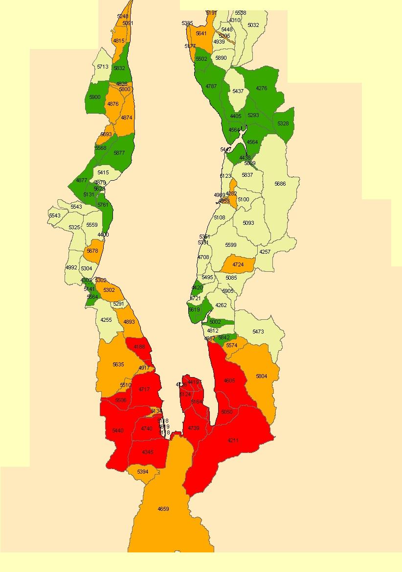
Squaxin Island Tribe rolls out new landscape analysis of Budd Inlet
Recently we’ve been presenting a landscape analysis to small groups in the area. Hopefully, our analysis will help kick-start a conversation about how to best approach restoring Budd Inlet.
Here is a press release about the project from the NWIFC:
The Squaxin Island Tribe has taken more than 20 years of studies and developed a resource to restore Budd Inlet. “We’ve taken every technical report, assessment and action plan written and come up with the ultimate Budd Inlet resource,” said Scott Steltzner, a biologist for the Squaxin Island Tribe.
Rather than writing a top to bottom restoration plan, the tribe created a way for practically any group to find out where to best apply their efforts. “This isn’t a straight up and down list of priority projects, but rather a way to find the project that’s right for a particular budget or effort,” Steltzner said. “If you have $25,000 and want to restore a shoreline, we can find a project for you. Or, if you have want to do projects that benefit shorebirds or forage fish, this tool can help you develop a strategy.”
The best thing about our work is that it doesn’t tell you what to do, just gives policy-makers the resources they need to make informed choices.
Here is our biologist Scott Steltzner giving a presentation on the analysis. Just click on the window below and you can hear Scott as he presents:
Here is a link to the spreadsheet Scott referred to in the presentation, and here is the complete map of the analysis.
Too see why a part of Budd Inlet was ranked in a particular way, you can find its number on the spreedsheet and find what attributes were associated to it.